
Northeast Overview - August 2026
Monthly Summary
PLEASE NOTE: Data is preliminary and subject to change.
Summary Statement
August and summer featured above-normal temperatures, precipitation extremes, and multiple inclement weather events.
Temperature
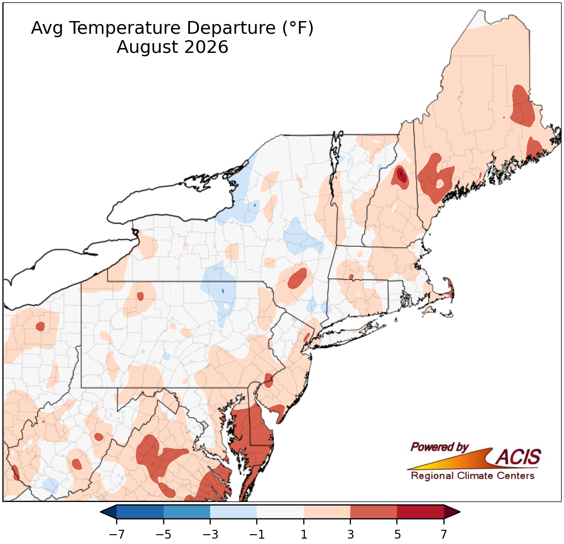
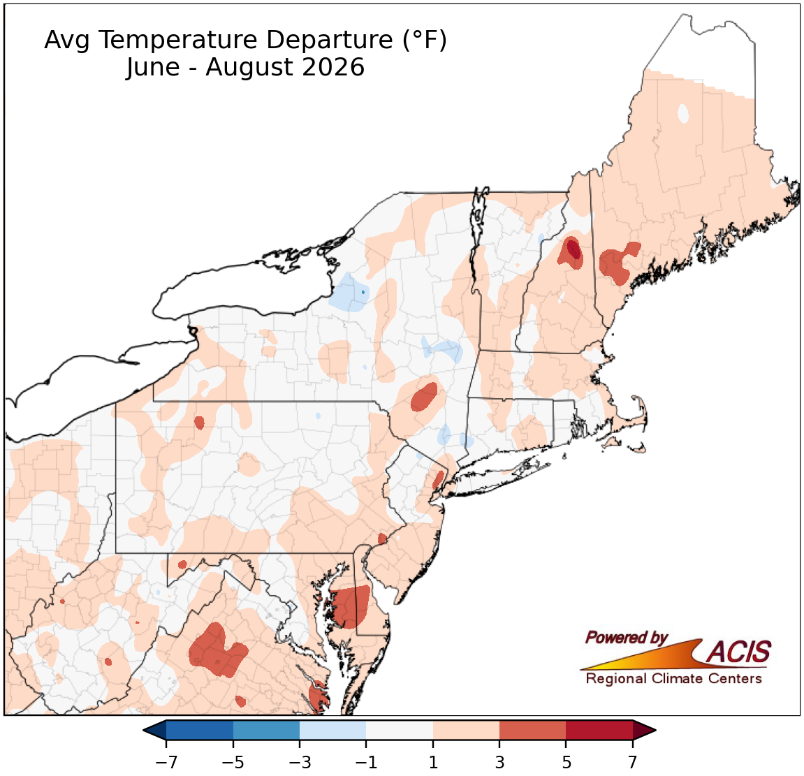
The Northeast’s average temperature for August was 69.6 degrees F, which was 0.9 degrees F above normal. August average temperatures for the 12 Northeast states ranged from 0.2 degrees F above normal in New York and Pennsylvania to 2.4 degrees F above normal in Delaware. This August ranked among the 20 hottest Augusts since record began in 1895 for eight of the states: Delaware, sixth hottest; Maryland, 10th hottest; Maine, 11th hottest; Rhode Island, 13th hottest; Massachusetts, New Hampshire, and New Jersey, 14th hottest; and Connecticut, 18th hottest. The Northeast had its 17th-hottest summer on record with an average temperature of 69.1 degrees F, 1.0 degree F above normal. Summer average temperatures for the 12 Northeast states ranged from 0.6 degrees F above normal in New York and Pennsylvania to 1.7 degrees F in Delaware. Summer 2026 ranked among the 20 hottest summers on record for 10 of the states: Delaware, third hottest; Maine, fifth hottest; New Hampshire and Rhode Island, seventh hottest; Maryland, eighth hottest; Massachusetts, 10th hottest; New Jersey, 12th hottest; Vermont, 13th hottest; Connecticut, 14th hottest; and West Virginia, 19th hottest.
Precipitation
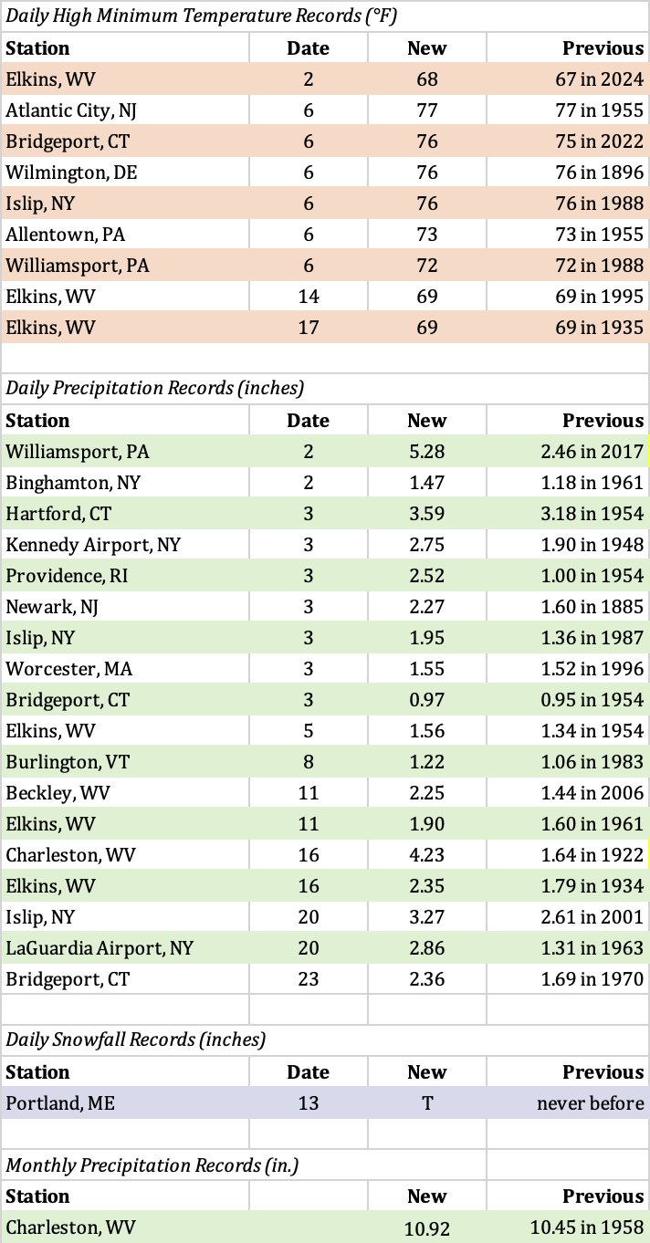
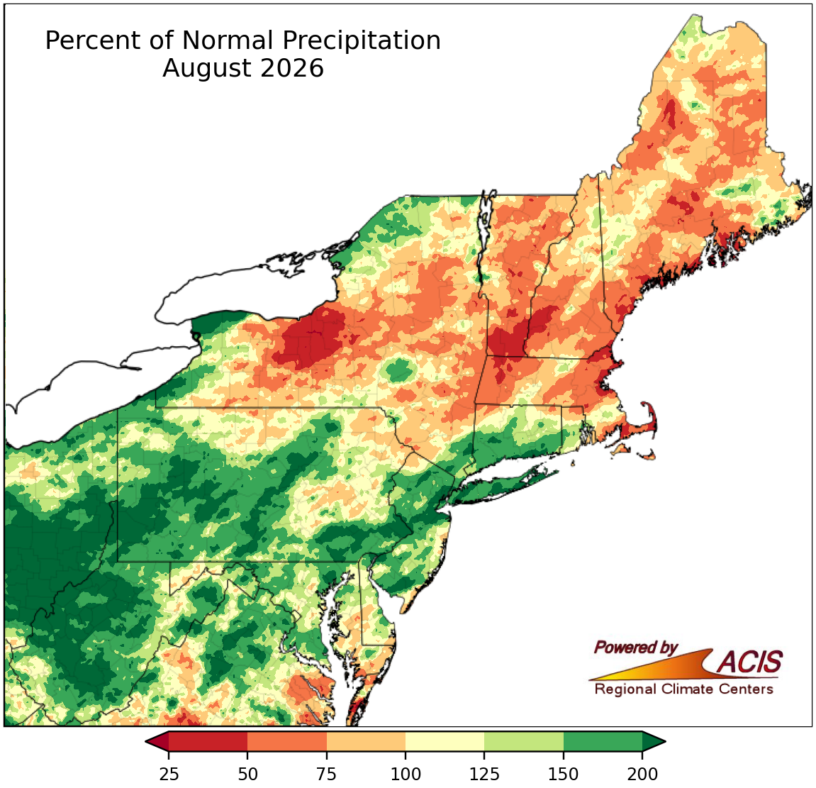
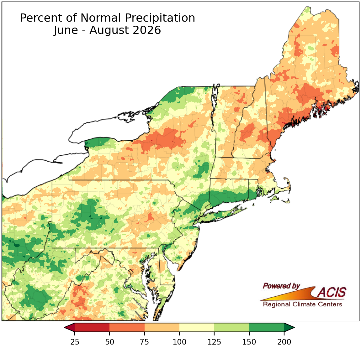
August was a wetter-than-normal month for the Northeast, with the region receiving 4.53 inches of precipitation, which was 113 percent of normal. August precipitation for the 12 Northeast states ranged from 72 percent of normal in Massachusetts to 175 percent of normal in West Virginia, with seven of the states wrapping up the month on the wet side of normal. This August ranked among the 20 wettest Augusts on record for three states: West Virginia, sixth wettest; New Jersey, 13th wettest; and Pennsylvania, 17th wettest. On August 2, Williamsport, Pennsylvania, had its wettest August day since its records began in 1895 with 5.28 inches of rain. The old record was 5.22 inches of precipitation on August 24, 1933. Charleston, West Virginia, had its wettest August day since its records began in 1892 with 4.23 inches of rain on August 16. This beat the old record of 4.13 inches from August 3, 1958. Charleston went on to have its wettest August on record with 10.92 inches of precipitation, topping the old record of 10.45 inches from 1958. Summer precipitation in the Northeast totaled 12.97 inches, which was 102 percent of normal. Precipitation for the summer season for the 12 Northeast states ranged from 81 percent of normal in Maine to 122 percent of normal in Rhode Island. It was West Virginia’s 11th-wettest summer on record. Bridgeport, Connecticut, had its wettest summer since its records began in 1949 with 21.24 inches of precipitation. This surpassed the old record of 20.23 inches of precipitation from 1972.
Drought
The U.S. Drought Monitor from August 4 showed 16 percent of the Northeast in drought and 22 percent of the region as abnormally dry. During August, plentiful precipitation in the Mid-Atlantic, southeastern New York, parts of southern New England, and southern New Hampshire allowed drought and/or abnormally dry conditions to improve. For instance, extreme drought was erased from the Northeast, while severe drought eased in West Virginia, New Jersey, New York, Rhode Island, New Hampshire, and most of Maryland, Pennsylvania, and Delaware. Moderate drought and/or abnormal dryness contracted along a path from West Virginia to southern New Hampshire. However, much of northern New England and upstate New York were drier, allowing conditions to deteriorate. For example, severe drought was introduced in Maine, while moderate drought was introduced in northeastern Vermont and expanded in Maine and abnormal dryness grew in coverage in Maine, northern and central New Hampshire, Vermont, and northern and central New York. The U.S. Drought Monitor from September 1 showed 18 percent of the Northeast in drought and 25 percent of the region as abnormally dry. Several drought-related impacts were reported in the region. Record-low USGS 7-day streamflow was confined to only a few spots like parts of Maine, central Maryland, and coastal New Jersey at times during August. Groundwater levels were record low at times during the month in several areas including parts of Maryland and New Jersey, southeastern Massachusetts, and southern Maine. There were a few reports of dry wells in Maine. Water conservation was encouraged in some areas, with a few water suppliers in parts of Pennsylvania and coastal Maine having mandatory water restrictions or watering bans. Lower-than-usual water levels in waterways, lakes, ponds, and wetlands were reported in northeastern Vermont, central New Hampshire, and Maine. In fact, in coastal Maine, reports noted that some small streams had dried up and low water levels affected rural firefighting operations. Reports from Maine also indicated that pastures and lawns were turning brown, crops and plants were suffering from moisture stress and stunted, hay growth was slower than usual, trees were dropping leaves prematurely, and farmers increased their use of irrigation. Further, there were reduced yields of crops such as potatoes, garlic, and peppers. A producer in northern Vermont stated that their corn crop was stunted and that they had to give cattle supplemental feed about a month earlier than usual due to slow pasture growth.
Notable Weather Events
Severe weather and/or flash flooding hit the Northeast frequently during August. There was a preliminary total of 17 tornadoes in the Northeast: eight in Pennsylvania, three each in Delaware and New York, two in Maryland, and one in New Jersey. For comparison, the average number of tornadoes during August (2001 to 2025 data) is two each in Pennsylvania and New York, one each in Maryland and New Jersey, and zero in Delaware. There were also hundreds of wind damage reports in August, particularly in the Mid-Atlantic. A few events are highlighted below.
- August 10 to 11 – There were severe thunderstorms and localized flash flooding in parts of the Mid-Atlantic. For example, as much as 4.50 inches of rain contributed to flash flooding in Somerset County, Pennsylvania, where the Youghiogheny River at Confluence rose nearly five feet in an hour. Floodwaters entered homes, inundated roads, and washed out bridges, resulting in several water rescues. An EF-0 tornado caused minor damage in Baltimore and Dundalk, Maryland. A few areas of straight-line winds downed trees in southwestern West Virginia. There were at least two people injured due to storms.
- August 12 to 13 – Severe storms struck New York and New England. For instance, straight-line winds of up to 105 mph caused damage along an 8.5-mile path in New Haven County, Connecticut. Storm reports noted dozens of downed trees and power poles, damage to homes and vehicles from fallen trees, the collapse of a wall and partial loss of a roof on a warehouse, and that another building had windows blown out and support columns shifted. Large hail of up to 3 inches fell in Broome County, New York.
- August 16 to 17 – West Virginia and Pennsylvania were the focal points for adverse weather events. Significant flash flooding occurred in portions of northern and central West Virginia, where floodwaters inundated buildings and submerged roads, leading to water rescues and at least one death. The flooding also caused several schools to delay their first day of the new school year. Two EF-0 tornadoes touched down in western Pennsylvania, with damage mostly confined to trees.
- August 20 – Eleven tornadoes touched down in the Northeast – five in Pennsylvania, three in Delaware, and one each in Maryland, New Jersey, and New York. The strongest tornado was an EF-2 in York County, Pennsylvania, that county’s strongest tornado since April 2011. The tornado ripped off sections of a school’s roof and blew out windows and tore siding off of several homes, resulting in one person sustaining injuries. Another tornado, an EF-1 in Lancaster County, tore roofs off two buildings, knocked down a section of a building’s brick wall, and caused a few small outbuildings to collapse. It was one of three tornadoes in Lancaster County that day, making it the first time the county has had three tornadoes in a day since records began in 1950. Delaware’s three tornadoes, all EF-1s, occurred in Kent County, making it the first time in six years that there were three or more tornadoes in a single day in that county or state. One of the Delaware tornadoes caused extensive damage to two Little League fields, led to the partial collapse of a warehouse’s concrete walls, and peeled off part of a motel’s roof. Nassau County, New York, had its strongest tornado since at least 2006 with an EF-1 that damaged dozens of vehicles and beach bungalows. An EF-1 tornado that damaged trees in Queen Anne’s County, Maryland, was the county’s strongest tornado since July 2017. Meanwhile, localized flash flooding occurred in parts of the Mid-Atlantic. For example, dozens of people were rescued from flooded roadways in Jersey City, New Jersey.
- August 27 – Two tornadoes damaged trees in Saratoga County, New York, making it the first day since July 5, 1992, the county had two or more tornadoes on the same day. Several areas across the Northeast experienced flash flooding. For example, in Berkeley County, West Virginia, water submerged roads and flooded basements and buildings, leading to multiple stuck vehicles and school closures. Several central Pennsylvania counties experienced flooding from 2 to 6 inches of rain that inundated roads, vehicles, and buildings, leading to water rescues. In parts of New Jersey and the New York City metro area, floodwaters overwhelmed roadways, train tracks, and basements, trapping motorists, leading to water rescues, and suspending train service.
Relevant Links (click to view)


Monthly Records